
For nearly 35 years, James Niehues has hand-painted some of the world’s most iconic mountains. But instead of hanging in art galleries, his work appears in the brochures and on the websites of the world’s ski resorts. And that’s just the way he likes it.
James Niehues sat down in his basement studio and took out his no.2 brush. With patient vertical strokes, he added the finishing touches to his latest canvas, Mad River Glen, a bowl-shaped valley, woven with ski trails, that sinks 2,000 vertical feet into Vermont’s Green Mountain Range. Autumn light filtered through the lonely high window, beyond which lay Denver, Colorado. Niehues didn’t pay it much attention. He rarely looks at real mountains when he’s painting.
There are probably tens of thousands of trees on the slopes of Mad River Glen, and Niehues has hand-painted every single one. He discriminates between conifers and deciduous trees, because skiers legitimately care about the difference. Trees at high altitudes are blue, caught in shade or lost in the ozone. Lower slopes are picked out in forest greens and pale sunrise gold. His mountains are usually frozen in a particular light, what American skiers call ‘Bluebird’, when the sun hits an acute angle and shadows catch on the snow, with a cloudless sky so blue it hurts the retinas.
On the walls of the studio hang other mountains. Boreal. Big Sky. Crested Butte. Kicking Horse. Deogyusan in South Korea. Well-skied slopes from Oregon to Maine, Idaho to North Carolina. Powder trails in New Zealand, Australia, Serbia, Chile and Japan. Niehues has painted them all. For over 30 years, he’s been almost the sole practitioner in a very niche artistic field: illustrated ski slope maps. His style has become so ubiquitous that it’s almost invisible; most skiers don’t even recognize it.
“Many skiers come up to me and we get talking and it comes out that I’m the trail map artist, and they all say, ‘Oh my gosh, I thought that was done by computers!’ And I say, ‘No, I paint all of those trees’,” Niehues says. He’s 74 years old with sharp blue eyes. White hairs rise from the dome of his head like snow-covered spruce trees. He has that native Colorado habit of dropping his middle t’s. Mountains become moun’uns.
RELATED: Forget Whistler, this is Tajikistan’s untouched, off-piste playground
Niehues began painting trail maps in 1987, when he was a 40-year-old graphic designer in Denver, struggling to put food on the table for his wife and four children. Colorado has always been his home. He grew up in Loma, a dusty town near the western border with Utah, surrounded by flat-topped mesas and empty red rock canyons. The sort of landscape that stretches the eye and tempts the palette. Niehues’ father would take him on rafting and hunting trips down the Colorado River. As a small child, he would sketch animals on the family farm.
It wasn’t until the ninth grade, when he was struck down with nephritis and bed-ridden for three months, that his mum bought him his first set of oil paints. Unable to get up, even to pee, Niehues began copying landscapes out of magazines. In the 1960s, he enlisted in the U.S. army and was sent to Germany, where he set-up a small art studio in the basement of a former SS barracks. By the mid-1980s, he was back in Denver, out of work and desperate, when he reached out to local ski trail artist, Bill C. Brown.
“If you see a computer map image, you instantly know it’s been done by a computer. It’s sterile. It reminds you of the office. With hand illustrations, you have so much variation in brush strokes and color, the amount of water in your brush. I can get to the top of the mountain, I can look around, I can feel it. That’s important.”
James Niehues
“Bill was from a southern Denver neighborhood, quite close to where I am now,” Niehues says. “I was hoping he had some work for me. He’d already been commissioned to paint Winter Park in Colorado, and he turned it over to me and said, ‘You go ahead.’ I mimicked Bill’s style as best I could. He took it up to the Winter Park manager and they liked it. Suddenly I was onto a whole new career, aged 40. And I couldn’t ski.”
More commissions followed. Word got around. At the time, there were only two other ski artists operating in North America, perhaps the world: Bill Brown and Hal Shelton, the legendary cartographer who had revolutionized topographical maps in the 1950s and ‘60s. But Shelton had more or less hung up his brush, and Brown was keen to explore other projects. Without really trying, Niehues had cornered the ski trail map market.
RELATED: How journalist Neil Shea unlocked the storytelling power of Instagram
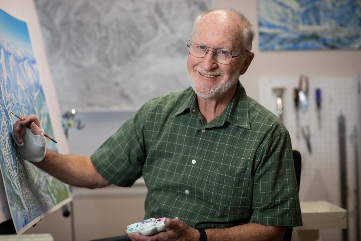
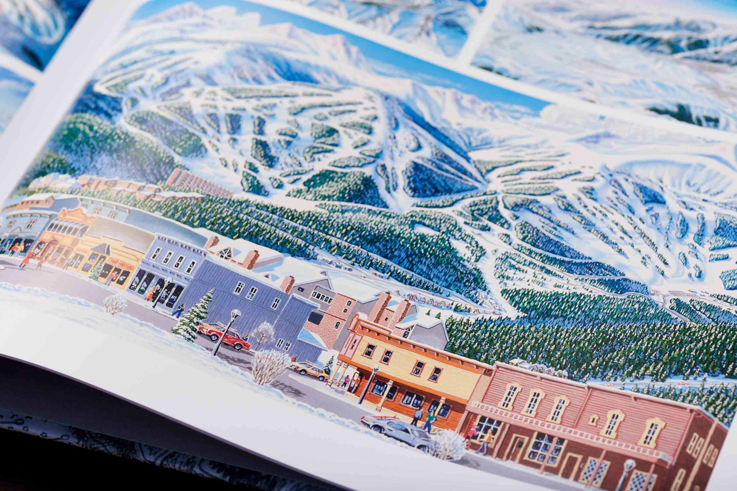
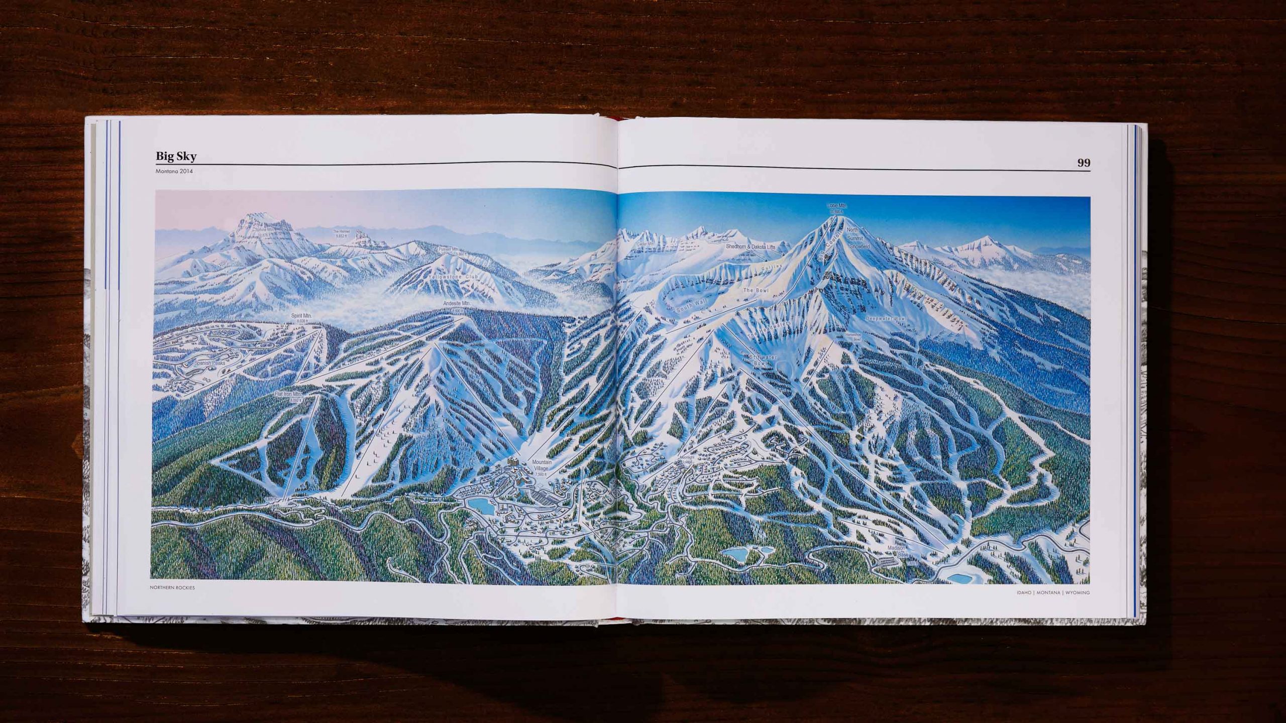
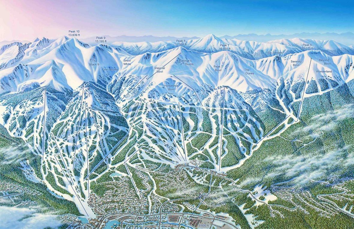
By the 1990s, he was painting 12 hours a day, seven days a week, resting his arm in a sling when it became too painful to lift the brush. “It takes about a week to sketch a large ski area, and three weeks to finish the final painting. I used to have them lined up through the summer months. Some years, I’d do 20 maps. Other years about 12.”
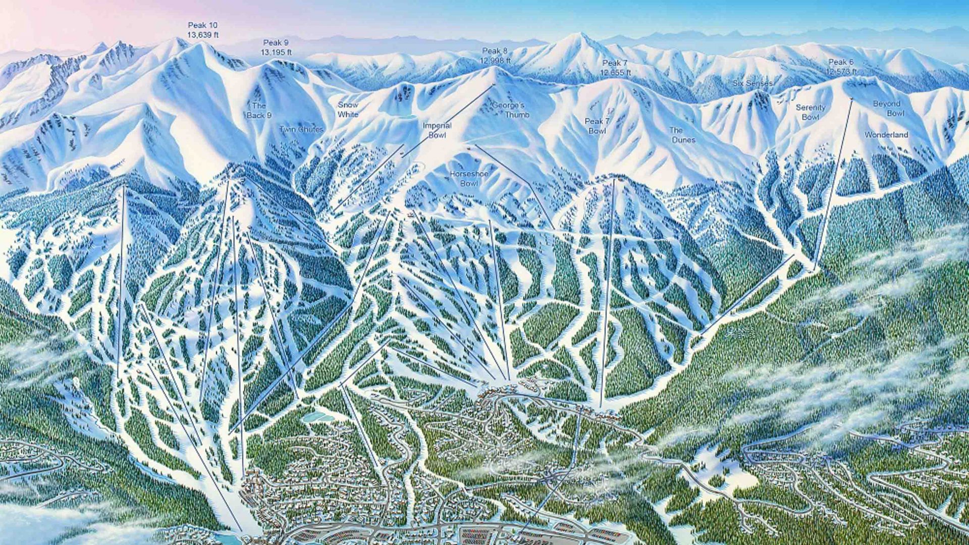
Niehues painted the trail map for Vail in Eagle County, the third biggest ski resort in the United States. He copied Winter Park onto Kodachrome slides and sent them to every ski resort he could think of, along with a note: “A quality illustration reflects a quality ski experience.”
This is something Niehues firmly believes. Only human hands can capture the specific geometry of the slopes. They have to be painted the way they’re skied. “If you see a computer map image, you instantly know it’s been done by a computer,” he says. “It’s sterile. It reminds you of the office. With hand illustrations, you have so much variation in brush strokes and color, the amount of water in your brush. I can get to the top of the mountain, I can look around, I can feel it. That’s important.”
A former client, Greg Ralph from Colorado’s Monarch Mountain, told a reporter in 2007, “It’s like hearing Michelangelo is available to paint the ceiling. You say, ‘Cool, we’ll take him.’”
Most ski trail maps begin the same way. In the old days, Niehues would hang out the side of a light plane or helicopter, a thousand feet above the ground, shooting aerials with his 35mm camera. (These days he uses a Nikon D7100 with an 18-2000mm zoom lens). Ski trail maps are usually painted from a god-like angle, gazing downward from the clouds, but the greatest challenge is flattening the perspective, squashing a three-dimensional mountain onto a Cartesian plane.
“Some mountains have 360 degrees of slopes,” Niehues says, “I have to fit them all onto one flat sheet.” Trails have to run vertically down the page. Specific gradients are measured in shades of ice blue. Each frosted conifer is carved by hand.
Niehues stitches the aerial shots together into an initial sketch, then sends it to the client for approval. “I tell them to visually ski down the sketch,” he says, “take a run and mentally ski down it.” Once the mountain skeleton is established, Niehues begins blocking in colors using gouache (pronounced guh-wash), an opaque watercolor that’s easy to fix and manipulate. With each pass he re-wets the canvas, adjusting the light, filling in the foliage, capturing relative levels of steepness.
It’s meticulous, painstaking work. Each 30×40-inch painting will be scanned at the photo lab in pin-point, 300mb detail (for later enlargement on mountain signage), so there’s no room for shortcuts. Bill Brown and Hal Shelton used to paint trees quickly, using textured sponges, but Niehues didn’t like the technique. In his maps, 10,000 trunks receive 10,000 brush strokes.
In the niche discipline of ski trail maps, Niehues has achieved artistic pre-eminence. He’s the Old Master of the mountains. A former client, Greg Ralph from Colorado’s Monarch Mountain, told a reporter in 2007, “It’s like hearing Michelangelo is available to paint the ceiling. You say, ‘Cool, we’ll take him.’”
But Niehues admits his ski map career might be drawing to a close, if only because there is a finite amount of mountains in the world. “You do paint yourself out of a job in some ways,” he says. “It’s a pretty small market, and it can’t really support more than one ski trail artist at a time. I was lucky enough to be one.”
—-
Find out more about ski map artist James Niehues here and his coffeetable book, The Man Behind The Map which features over 200 hand-drawn ski resort trails.
James Shackell is a freelance journalist with words in The Huffington Post, Red Bull, Canadian Traveler and Smith Journal. One day, he'll be bumped to business class, and you'll never hear the end of it.